The Cartographer 1.2 is here, with awesome navigation features The Cartographer 1.2 is here, with awesome navigation features
  • Home
  • Posts
  • Home
  • Posts

The Cartographer 1.2 is here, with awesome navigation features

The Cartographer Google My Maps iPhone App v1.2 with compass
We’ve recently released version 1.2 of our vintage-styled Google My Maps app The Cartographer!

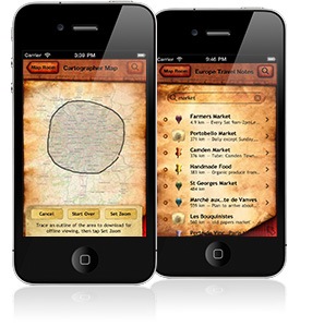
The new version introduces Navigon support, so you can get turn-by-turn navigation to any placemark on your map — this is great for researching then running errands, home or abroad. For example, need a new iPad? Search for “Apple Store” on Google Maps, click “Save To…” and choose a My Map (or use the new Clipper on any webpage with an address), then open it in The Cartographer, select the new placemark, and navigate there. Totally seamless.

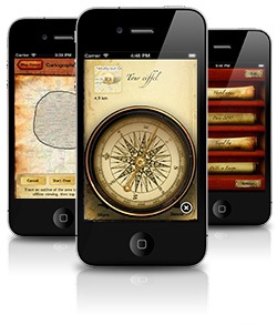
The other new feature is an in-app compass which provides bearing and distance information to the selected placemark. A needle points to your destination, while the dial shows which way’s north. Particularly useful for hiking — we used this just the other week in Exmoor National Park, and it was indispensable.

Grab The Cartographer 1.2 on the App Store, or find out more.

Read More

Introducing The Cartographer Clipper: Clip any website to Google My Maps

The Cartographer Clipper
I’m pleased to present The Cartographer Clipper, the perfect accompaniment to The Cartographer!

The Clipper is a bookmarklet that works in any modern web browser, and lets you clip information from any website — hotel directories, restaurant websites, even forum postings — to Google My Maps. Addresses are auto-discovered via some super-sleuthing magic, images pulled out and any selected text is placed into the description.

You can save to an existing map, or create a new one on the spot.

It’s great for doing travel or errand research — find a good hostel (or just the closest Apple store!), just click the “Clipper” button, then “Save”, and it’ll appear on your maps in The Cartographer, all automatically.

It’s free for use, and all it needs is any modern web browser, and a Google account.

Install The Cartographer Clipper here.

It’s still in beta, so do let me know if you have any trouble!

Read More

Breaking the limits: Storing data bigger than 1 Mb in Google App Engine’s Datastore

Google App Engine is a fantastic platform for hosting webapps, and a great resource for iOS developers who need an online component to their products. It’s hard to believe that the service is essentially free! I’m using it with The Cartographer, but I found myself coming up against a hard limit with the datastore.

You see, the datastore limits entities to 1 Mb. I’m trying to store XML data in there, and sometimes that can exceed the 1 Mb limit.

XML being the verbose creature that it is compresses very nicely, so it occurred to me that if I selectively compress the larger blocks, I should be able to quite easily squeeze in underneath the limit. Sure enough, a 1.6 Mb XML block compressed into about 200 Kb.

App Engine makes it very easy to define custom properties on data models, so I’ve written a CompressibleTextProperty class that automatically compresses/decompresses properties above a certain size. This means that there’s no performance loss for entities that are small enough to fit easily, but still enables the storage of bigger blocks of content.

The alternative was to break entities up into several different database entities, but this sounded like much more work, and sounded much less elegant.

So here’s what I came up with — it’s used the same way the other Property types are used.

Read More

The Cartographer is one of the 10 finalists for Best Travel App in Best App Ever 2010!

Vote for
The Cartographer
in
Best Travel App

I’m very excited to announce that The Cartographer is one of the 10 finalists in Best App Ever 2010’s Best Travel App category.

Thanks so much for your nominations!

Voting is now open until the 25th of January – please do! (And then tell all your friends!)

Read More

Import maps from Google Earth to The Cartographer

Export from Google Earth to The Cartographer
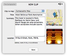
I’ve just implemented a way to import maps from Google Earth, which, like Google My Maps, allows you to create and edit groups of placemarks.

It’s pretty easy:

  • Right-click on the group in Google Earth that you’d like to import (My Places to get everything)
  • Click “Email”
  • Address the email to [email protected]
  • Wait a minute or two, and you’ll get an email back
  • Tap the link, if you’re reading the email on your iPhone, and your new map will open straight up in The Cartograper. Otherwise, type the URL into The Cartographer’s “Add Online Map” feature, to load the map.

Voila!

Side note: This also works with any old KML files you have lying around – just email them to [email protected].

Read More

Easy inclusion of OpenSSL into iOS projects

Oddly, iOS doesn’t provide any OpenSSL implementation at all — If you want to do anything with crypto (like checking signatures, checksumming, etc.), you have to build in the library yourself.

I came across a great XCode project wrapper for OpenSSL yesterday, by Stephen Lombardo. This is an XCode project file that contains a target to build OpenSSL from source, and works with both Mac and iOS projects. I made some modifications to it, in order to make it work by just dropping in the OpenSSL source tarball, without having to dirty up your source tree with the extracted OpenSSL distribution.

Here’s how to use it:

  1. Download the OpenSSL source.
  2. Put the downloaded OpenSSL source tar.gz into the same folder
    as openssl.xcodeproj (I put it in Library/openssl within my project tree).
  3. Drag the openssl.xcodeproj file into your main project tree in XCode.
  4. Right-click on your project target, and add openssl.xcodeproj under “Direct
    Dependencies” on the General tab.
  5. On the Build tab for your project’s target, find the “Header Search Paths”
    option, and add the path:
    > $(SRCROOT)/Library/openssl/build/openssl.build/openssl/include

    (Assuming you’ve put openssl.xcodeproj at the path Library/openssl — adjust as necessary).

  6. Expand your target’s “Link Binary With Libraries” build stage, and drag
    libcrypto.a from the openssl.xcodeproj group.

Then, you can just import and use as normal (#import, etc).

Download it here

Read More

The Cartographer featured in “What’s Hot” on the App Store

We were rather thrilled this morning to see that Apple have featured The Cartographer in the “What’s Hot” section on the App Store! That’s the second feature this month, after being featured under “New and Noteworthy” — I guess someone up there (in Cupertino!) likes us.

So, that’s our Christmas made merry!*

May yours be too.

* (but, you know, you could always make it merrier by nominating The Cartographer for the Best App Ever awards!)

Read More

Announcing The Cartographer 1.1, with Offline Map Downloading, Map Search, and Bulk Publishing

We’ve just released The Cartographer version 1.1!

New features include:

  • Bulk-download offline maps
  • View placemarks in a list, mass-publish placemarks, and search placemarks
  • Search the map for street names, towns, landmarks and more

The Cartographer Version 1.1 with Offline Map Downloading and List View
Our biggest and most-requested new feature is offline map downloading — now, you can select a whole map region to download, and a level of detail, and The Cartographer will download the entire street map to your iPhone, for viewing offline. This video shows how it works.

The second main new feature is map searching, so you can search for places by name. A tap converts search results to placemarks you can add to your map.

Bulk placemark publishing lets you make lots of placemarks while you’re away from Internet access, and then when you have Internet access, publish them to your map all at once.

And finally, a new list view shows you all placemarks on your map, ordered by how far away they are. You can also search your placemarks by their name or description.

We hope you like The Cartographer 1.1! We sure do.

Grab it on the iPhone App Store for $3.99.

Read More

Hi! I'm Michael Tyson, and I run A Tasty Pixel from our home in the hills of Melbourne, Australia. I occasionally write on a variety of technology and software development topics. I've also spent 3.5-years travelling around Europe in a motorhome.

I make Loopy, the live-looper for iOS, Audiobus, the app-to-app audio platform, and Samplebot, a sampler and sequencer app for iOS.

Follow me on Twitter.

Posts pagination

« 1 … 15 16 17 … 36 »
© 2021 A Tasty Pixel.